From India to Asia: How Google's AI is cultivating a new future for agriculture
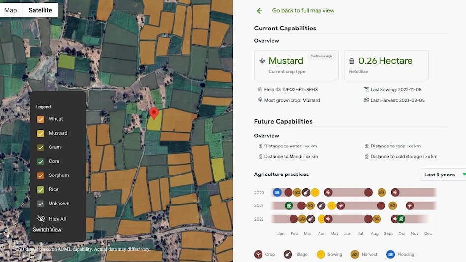
In a groundbreaking initiative, Google is set to extend its innovative agricultural AI models beyond India, reaching the Asia-Pacific region. The Agricultural Landscape Understanding (ALU) and Agricultural Monitoring and Event Detection (AMED) APIs, which have already transformed agricultural practices in India, are now in the hands of select testers in Malaysia, Indonesia, Vietnam, and Japan. These advanced models utilize remote sensing and machine learning to provide localized insights, tackling some of agriculture's most persistent challenges. To delve deeper into this technological advancement, I spoke with Alok Talekar, who leads Agriculture and Sustainability Research at Google DeepMind, and Avneet Singh, a Product Manager from Google's Partner Innovation team. They highlighted the complexities of agriculture in India, emphasizing how it varies significantly across regions. Talekar noted, "In agriculture, everyone aims to do the right thing; however, the diversity across the country means that the tools and information available are often inadequate." Historically, agricultural data has been collected at a macro level—district or village-wide. Singh pointed out that this lack of granularity hampers effective decision-making. "We need insights at the individual field level to provide the right interventions and advice," he explained. The absence of detailed data leads to generic and inefficient farming practices. Talekar stressed that a one-size-fits-all solution is impractical, as conditions vary greatly between states and countries. Google's response to these challenges involves two foundational AI models designed to support an entire ecosystem. The first, Agricultural Landscape Understanding (ALU), launched in India in late 2024, segments the agricultural landscape using satellite imagery to delineate fields and water bodies, creating a comprehensive digital map. Following this, the Agricultural Monitoring and Event Detection (AMED) API, introduced in mid-2025, offers real-time insights into individual fields, tracking critical activities such as sowing and harvesting. This model updates every 15 days, ensuring that farmers have access to the most current information. Both models harness vast amounts of geospatial data, primarily sourced from satellite imagery. Talekar explained that Google’s long-standing investment in geospatial technology gives them a competitive edge, making advanced data analysis accessible to smallholder farmers who previously relied on larger agricultural corporations. However, Talekar acknowledged the challenges of maintaining accuracy across various regions. "No model can be perfectly accurate everywhere. Our goal is to achieve a level of statistical accuracy that is useful for each specific context," he stated. Google employs a robust validation process that includes comparisons with government data and independent checks by third-party organizations. The practical benefits of these models are evident in how they empower farmers, even those unfamiliar with advanced technology. Agricultural partners can leverage Google's APIs to optimize crop yields by identifying the specific conditions of fields and providing tailored advice based on historical data. Moreover, this technology can significantly enhance farmers' access to credit. Talekar illustrated the difficulties many farmers face in securing loans due to cumbersome verification processes. Google’s models offer a low-cost, unbiased way to confirm agricultural activities, reducing risks for financial institutions and potentially unlocking fair credit options for millions. Projects across India are already implementing these models effectively. For instance, the national Krishi DSS platform uses the APIs to aid policymakers, while the Government of Telangana applies them in its open data exchange for agricultural solutions. Additionally, the think tank Council on Energy, Environment and Water (CEEW) plans to utilize these tools to create income support systems promoting climate-friendly farming practices. The success of this India-centric approach has paved the way for expansion into Malaysia, Indonesia, Vietnam, and Japan. Talekar expressed optimism about the potential impact of these APIs in the Asia-Pacific region, reiterating the belief that solutions tailored to India's challenges can also benefit the global agricultural landscape. Regarding data privacy, Singh assured that the information used is strictly geospatial and devoid of any personally identifiable data, ensuring the protection of farmers' privacy.
India's Crackdown on Open-Source Messaging App Raises Legal Concerns
The Indian government's recent initiative to enforce restrictions on Jack Dorsey's offline Bluetooth messaging applicati...
TechCrunch | Jul 24, 2026, 17:10
Trump Signals Trade War with EU Over Tech Giants' Fines
In a bold move, President Donald Trump announced on Friday that his administration would initiate a trade investigation ...
CNBC | Jul 24, 2026, 18:15
Tech Giants Unite to Advocate for Open AI Models Amid Regulatory Concerns
In a bold move reflecting their shared vision for the future of artificial intelligence, leading tech figures have come ...
Business Insider | Jul 24, 2026, 14:45Midjourney Expands Horizons with Acquisition of Co-Star Astrology App
In a significant move to diversify its offerings, Midjourney, the AI lab renowned for its innovative image and video gen...
TechCrunch | Jul 24, 2026, 15:25
Tech Giants Unite to Advocate for Open-Weight AI Models Amid Regulatory Concerns
A coalition of major technology companies, including Nvidia, Microsoft, Meta, and Palantir, has issued a call to action ...
CNBC | Jul 24, 2026, 14:30